

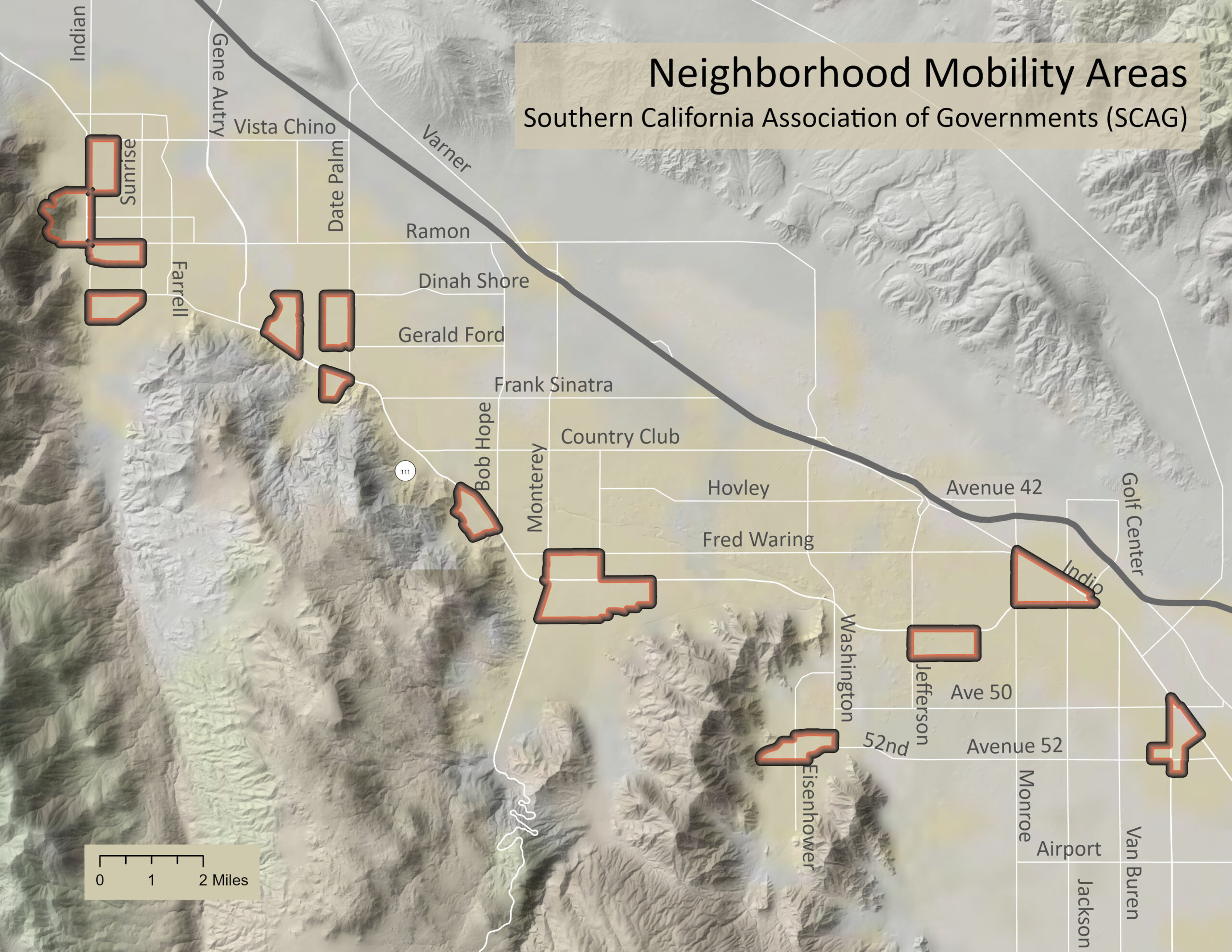
My role at the Coachella Valley Economic Partnership is rather unique. You don’t see many Geographic Information Specialists (GIS) employed by economic development agencies in regions of our size let alone a Director of Analytic Services. I’m proud to be the first of its kind at CVEP and grateful to our CEO Joe Wallace for championing data-driven development in the valley. Underpinning data-driven decision making is DATA. Thankfully, the GIS community has committed itself to open data sharing. One such agency at the forefront of these efforts is the Southern California Association of Governments (SCAG). Their SCAG GIS Open Data Portal is an excellent one-stop-shop for geographic data about Southern California. Today’s Digest utilizes one such interesting dataset: Neighborhood Mobility Areas (NMA’s). This map identifies the Coachella Valley’s NMA’s. What does our preponderance of NMA’s say about the quality of life in the Coachella Valley?
We’ve got our spectacular natural setting and 350+ days of sunshine. We have world-class entertainment and culinary venues. We’ve got recreation galore. All this, and more, makes the Coachella Valley a wonderful place to live. With 9 cities and many unincorporated areas, each with their distinct charms, about any personality can find “their place” in the valley.
Like most cities and regions, the Coachella Valley is comprised of many unique neighborhoods and housing developments. This map locates SCAG’s designation of special kinds of neighborhoods, Neighborhood Mobility Areas (NMAs). We’ve got 13 of them, spread throughout the valley in almost every town. Four specific characteristics are used to designate an NMA:
- High road intersection density
- Low-speed streets
- A significant mix of land uses
- High accessibility to “everyday” destinations – amenities within one mile using street network distances
These are compact neighborhood centers with a strong sense of place. Residents can go about their daily routines – like going to the grocery or enjoying a lunch out – by walking, biking, or other non-automotive transport. In the entire SCAG region, about 38% of all such trips are three miles or less, easy distances by walking or biking. But 78% of these trips are made by automobile.
As part of SCAG’s state and federally-mandated, four-year update of Connect SoCal (Southern California’s Regional Transportation Plan/Sustainable Communities Strategy (RTP/SCS)), SCAG promotes fortifying existing NMAs and creating new ones with the qualities of:
- Connectedness and vibrancy
- Compactness and mixed-use
- Walkability and livability, with ample green spaces, public amenities, and affordable housing options.
SCAG outlines strategies for creating Connected communities, including regulatory changes, new programs, innovative partnerships, and improvements to roadways and other existing infrastructure. “The strategies coalesce around creating an environment that is supportive of new local services and destinations and improving safety and access for people who are not driving automobiles to local destinations.”
The Coachella Valley continues to attract new residents from expensive and dense coastal communities. As this burgeoning population continues to grow they will be looking for the very type of neighborhoods SCAG calls Neighborhood Mobility Areas. Promoting such development here can only add to our already high standard of living.


