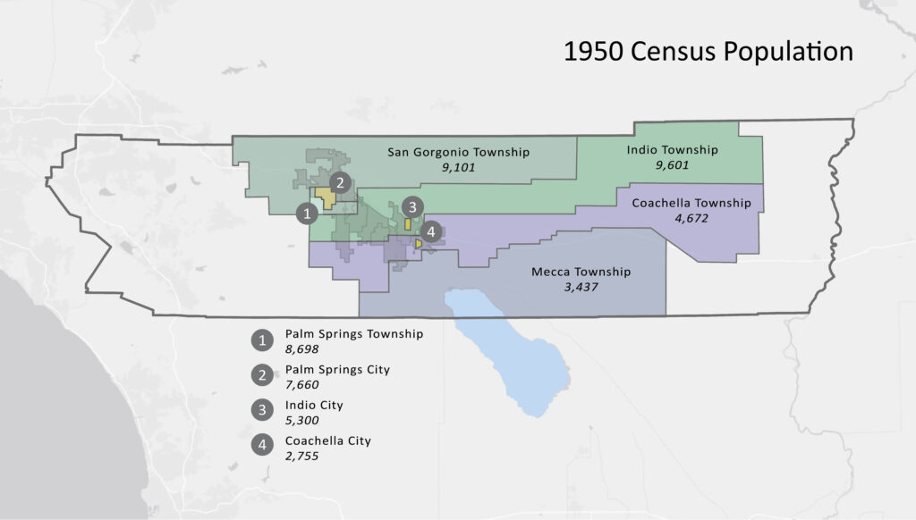
It wasn’t April fools! On April 1 the US Census Bureau released 1950 Census records. After 72 years have passed, the Census releases all answers to previously secret census forms. These handwritten forms are now available for historians and curious relatives to explore. That made us wonder. What did the Coachella Valley look like at the time of the 1950 Census? Well – very, very different. This map shows the boundaries used for the 1950 census with the tabulated populations for each. Note that there were only three incorporated cities in 1950 – Indio (1930), Palm Springs (1938), and Coachella (1946). The small polygons for the cities show the much smaller boundaries of 1950. You can see the pale boundaries of the current city boundaries behind. The rest of our valley cities were incorporated in:
1963 Desert Hot Springs
1967 Indian Wells
1973 Palm Desert
1973 Rancho Mirage
1981 Cathedral City
1982 La Quinta
The census boundaries comprising the Coachella Valley in 1950 had a total population of 51,214, between the current population of Palm Springs (47,600) and Cathedral City (54,130). The current population estimate for the Coachella Valley is 460,800, a nine-fold increase from 1950!
In 1950, Riverside County’s population was decidedly more rural – 49% of the population, with a total population of 170,050, compared to 317,800 today. And California’s population was 10,580,200, compared to 39,237,800 now.


